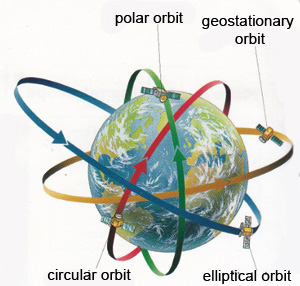
 Polar and Geostationary Satellites
A geostationary satellite is an earth-orbiting satellite, placed at an altitude of approximately 35,800 kilometers (22,300 miles) directly over the equator, that revolves in the same direction the earth rotates (west to east). A polar orbit is one in which a satellite passes above or nearly above both poles of the body being orbited (usually Earth) on each revolution.
Satellites orbit Earth at different heights, different speeds and along different paths. The two most common types of orbit are “geostationary” and “polar”.
A geostationary satellite travels from west to east over the equator. It moves in the same direction and at the same rate Earth is spinning. A geostationary satellite circles the Earth once every 24 hours, the same amount of time it takes for the Earth to spin on its axis.
From Earth, a geostationary satellite looks like it is standing still since it is always above the same location. That is why when we turn our home satellite dish to receive the TV signal from a particular geostationary satellite, we don't have to keep jumping up to adjust its position.
Geostationary satellites can be positioned right over the areas where they are needed. They can also be used as spy satellites, because they remain constantly over a region of interest.
Polar‐orbiting satellites travel in a north‐south direction from pole to pole. As Earth spins underneath, these satellites can scan the entire globe, one strip at a time.
A polar orbit may be several hundred miles to several thousand miles above Earth. A satellite in a relatively low orbit circles the Earth approximately 14 times each day, while higher–orbiting satellites orbit less frequently.